COURSE OVERVIEW
OE0096 : Introduction to Hydrography: Principles and Applications
OVERVIEW
| COURSE TITLE | : | OE0096 : Introduction to Hydrography: Principles and Applications |
| COURSE DATE | : | Aug 10 - Aug 14 2025 |
| DURATION | : | 5 Days |
| INSTRUCTOR | : | Mr. Sergey Kole |
| VENUE | : | Dubai, UAE |
| COURSE FEE | : | $ 8000 |
| Request For Course Outline | ||
Course Description
This practical and highly-interactive course includes real-life case studies and exercises where participants will be engaged in a series of interactive small groups and class workshops.
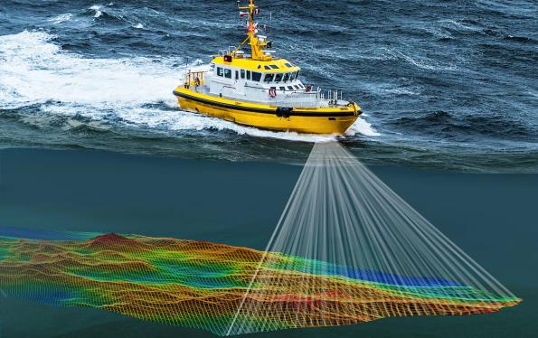
This course is designed to provide participants with a detailed and up-to-date overview on the Introduction to Hydrography: Principles and Applications. It covers the scope of hydrography and its importance in petroleum exploration; the purpose of hydrographic surveys including hydrographic survey standards and regulations; the geodesy and coordinate systems in hydrography; the fundamentals and data acquisition of bathymetry; the hydrographic data quality control and management; and the hydrographic survey platforms.
Further, the course will also discuss the bathymetric survey techniques; the tides and water levels in hydrography; the positioning and navigation in hydrography and sonar and acoustic systems; integrating remote sensing in hydrography; the data acquisition and pre-processing as well as bathymetric data processing and visualization; the seabed classification, sediment analysis, hydrographic charting and nautical mapping; and the error analysis, data correction techniques.
During this interactive course, participants will learn the role of hydrography in offshore drilling; the seabed mapping for pipeline routing and platform installation; the underwater infrastructure inspection and maintenance; the coastal and marine environmental monitoring; the hydrographic risk assessment for offshore operations; and the hydrographic surveying for port and harbor development through depth measurement and dredging planning as well as navigational safety and ship channel maintenance.
link to course overview PDF
This course is designed to provide participants with a detailed and up-to-date overview on the Introduction to Hydrography: Principles and Applications. It covers the scope of hydrography and its importance in petroleum exploration; the purpose of hydrographic surveys including hydrographic survey standards and regulations; the geodesy and coordinate systems in hydrography; the fundamentals and data acquisition of bathymetry; the hydrographic data quality control and management; and the hydrographic survey platforms.
Further, the course will also discuss the bathymetric survey techniques; the tides and water levels in hydrography; the positioning and navigation in hydrography and sonar and acoustic systems; integrating remote sensing in hydrography; the data acquisition and pre-processing as well as bathymetric data processing and visualization; the seabed classification, sediment analysis, hydrographic charting and nautical mapping; and the error analysis, data correction techniques.
During this interactive course, participants will learn the role of hydrography in offshore drilling; the seabed mapping for pipeline routing and platform installation; the underwater infrastructure inspection and maintenance; the coastal and marine environmental monitoring; the hydrographic risk assessment for offshore operations; and the hydrographic surveying for port and harbor development through depth measurement and dredging planning as well as navigational safety and ship channel maintenance.
TRAINING METHODOLOGY
This interactive training course includes the following training methodologies:
LecturesPractical Workshops & Work Presentations
Hands-on Practical Exercises & Case Studies
Simulators (Hardware & Software) & Videos
In an unlikely event, the course instructor may modify the above training methodology for technical reasons.
VIRTUAL TRAINING (IF APPLICABLE)
If this course is delivered online as a Virtual Training, the following limitations will be applicable:
| Certificates | : | Only soft copy certificates will be issued |
| Training Materials | : | Only soft copy materials will be issued |
| Training Methodology | : | 80% theory, 20% practical |
| Training Program | : | 4 hours per day, from 09:30 to 13:30 |
RELATED COURSES

OE0206 : Operations of Nav. Aids,Compasses,ARPA Radar,GPS,Echo Etc
- Date: Jan 11 - Jan 15 / 3 Days
- Location: Dubai, UAE
- Course Details Register
OE0040 : OPTIMIZING OIL & GAS MARINE TERMINALS Operations, Management & Safety in Accordance with International Standards
- Date: Jan 11 - Jan 15 / 3 Days
- Location: Muscat, Oman
- Course Details Register
.jpg)
OE0445(AR1) : Tanker & Marine Terminals: Operations, Charter Parties, Laytime, Demurrage, Loss Control, Audits, Rules & Regulations
- Date: Jan 11 - Jan 15 / 3 Days
- Location: Doha, Qatar
- Course Details Register

OE0071 : Offshore Drilling Operations
- Date: Jan 18 - Jan 22 / 3 Days
- Location: Doha, Qatar
- Course Details Register